Our Services
-
We use EM locating technology to accurately identify both metallic and non-metallic facilities that have tracer wire. This is the most commonly used and necessary form of locating.
-
Subsurface is at the forefront of cutting-edge laser scanning technology, providing unparalleled capabilities for diverse industries and applications. Our state-of-the-art laser scanning solutions are designed to deliver high-precision, three-dimensional representations of physical spaces and objects. With a commitment to innovation, our skilled team harnesses the power of laser scanning for applications such as topographic mapping, building information modeling (BIM), infrastructure development, and industrial plant design. Our advanced equipment ensures rapid data acquisition without compromising accuracy, enabling us to capture intricate details with exceptional resolution. Subsurface is dedicated to meeting the unique needs of our clients, offering tailored solutions that enhance project efficiency, reduce costs, and facilitate informed decision-making. From comprehensive site surveys to detailed structural analysis, our laser scanning technology stands as a reliable and indispensable tool for projects demanding precision and a thorough understanding of spatial environments
-
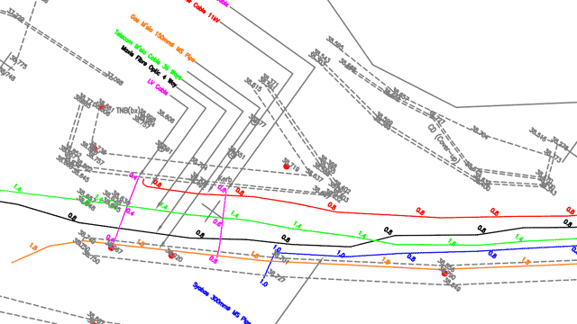
We use Survey Grade GNSS/GPS units and specialized software to produce highly accurate sub-centimeter maps that we maintain throughout the lifetime of your project. With this data, we can quickly remark all utilities mapped. We also cross-reference this data for future projects in the same area. Contact one of our GIS techs today to learn more.
Please note that we do not have a PLS on staff, and we recommend contacting a licensed surveyor for all surveying needs.
-
Our utility locating service combines both GPR and EM locating technologies. While EM locating is ideal for metallic facilities with tracers, GPR is the most effective tool for detecting non-metallic lines, such as water and sewer lines. This sets us apart from our competitors, who often only offer EM locating. If the facility you need to locate is made of plastic with no tracer wire, they may not be able to help you. However, for us, that's just the beginning of what we can do for you.
-
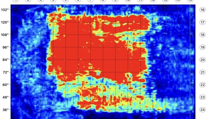
We offer concrete scanning services to inspect concrete slabs or columns before drilling or coring for renovations and new construction projects. Our concrete scans are conducted using Ground Penetrating Radar (GPR) technology, which ensures quick and accurate inspections. GPR is both safe and noninvasive; it analyzes the subsurface by using transmitted waves and their reflected signals to detect embedded objects. With this technology, we accurately locate and mark Rebar, PT, infrastructure, and any other obstructions in concrete. Additionally, we can provide 2D and 3D images post-inspection. Our concrete scanning service is suitable for inspecting balconies, beams, bridges, ceilings, columns, decks, encasements, floors, pylons, roofs, slabs, tunnels, and walls.
-
With our state-of-the-art CCTV sewer inspection cameras, we can swiftly capture high-quality images of the interior of most sewer lines. Our services are utilized by various real estate agents to provide homeowners with qualified inspections required for purchasing a new property. Moreover, we possess commercial-grade equipment, enabling us to work seamlessly with municipalities and contractors for mainline sewer inspections.
-
Our team at Subsurface GPR has over five years of experience in the GIS industry, covering a wide range of tasks from analyzing and manipulating data to creating new GIS products. In addition, one of our experts holds a certificate in GIS from the University of California Davis. With our expertise, we are well-equipped to handle all of your GIS needs. We proudly serve clients in Oregon and Washington and are willing to travel for projects nationwide.